Only the older ones of you will 'get' the title of this posting, but in essence, it had been a number of years since Sue or I had been to the Yorkshire dales to walk. Today, we were to address that!
Although we've both walked Malham and Goredale scar before, it's just SUCH an attractive walk, we decided to do it again today. The weather wasn't as good for photo's as last week, but the temperature and breeze were perfect.
We parked up in Malham centre, and started the day with a cup of coffee in this cafe with the clever sign - a boot cut in half, one half on each side of the sign - brilliant!
.JPG) It really is picture book/chocolate box country around here.
It really is picture book/chocolate box country around here.This is as fine an example of a clapper bridge as you'll ever see.
.JPG) After a short walk across meadows, with quite a lot more company than we're used to, mid week (well, it IS holiday time), we reached Janet's Foss, a small but pretty waterfall near Gordale Scar.
After a short walk across meadows, with quite a lot more company than we're used to, mid week (well, it IS holiday time), we reached Janet's Foss, a small but pretty waterfall near Gordale Scar..JPG)
We pressed on up into Goredale. Here it is, a mighty scar it is too, all cut out by the action of water on the limestone. There was what we assumed to be a painting class, as there were about ten painters in all.
.JPG)
This is the falls in the scar.
It looks a little insignificant in this picture, but to progress, you must climb up it.
.JPG) This is the view from the top when you have.
This is the view from the top when you have..JPG)
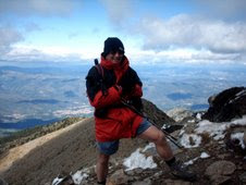
This is what you have to do to GET that view - poor Susie (in truth, she relishes this sort of challenge).
.JPG) The hard part over, it's just a scramble now to get to the top.
The hard part over, it's just a scramble now to get to the top..JPG) Another falls at the top, this one comes out of a hole in the rock face. I'm told, when in spate, it's a fantastic sight as the water comes out of the hole like a fire hose!
Another falls at the top, this one comes out of a hole in the rock face. I'm told, when in spate, it's a fantastic sight as the water comes out of the hole like a fire hose!.JPG) Your rewards for all that climbing - Goredale.
Your rewards for all that climbing - Goredale.Isn't it LOVELY?
.JPG) This is Limestone pavement. there's a lot of it in this area. It's where the water has worn the once-flat limestone into what looks like an enormous jigsaw puzzle.
This is Limestone pavement. there's a lot of it in this area. It's where the water has worn the once-flat limestone into what looks like an enormous jigsaw puzzle.Incredible to think that ALL this is the remains of tiny creatures that lived here when it was a warm, tropical sea millions of years ago.
.JPG) Sue knows a lot about this, and went on to explain............
Sue knows a lot about this, and went on to explain.............JPG) ......yes dear.......yes dear..........
......yes dear.......yes dear...........JPG) After walking for a while along the GORGEOUS grassy tracks above Goredale, we reached Malham Tarn, where we were to have lunch. The sky was marginally better still not bright.
After walking for a while along the GORGEOUS grassy tracks above Goredale, we reached Malham Tarn, where we were to have lunch. The sky was marginally better still not bright..JPG) After this, we went to 'the dry valley'. This is the path leading down into it.
After this, we went to 'the dry valley'. This is the path leading down into it..JPG) Sue & I at the head of the valley.
Sue & I at the head of the valley..JPG) Looking back up the valley after descending the path.
Looking back up the valley after descending the path..JPG)
We walked out of the valley and made our way to the top of Malham cove. As I said, a little more company than we're used to. Every man and his dog up here today!
.JPG) The view from the top of the cove - magnificent!
The view from the top of the cove - magnificent!.JPG) ....and if you walk to the edge and look down........
....and if you walk to the edge and look down.........JPG)
This is what limestone pavement looks like close up. A real ankle-breaker, if you're not careful.
It hosts a lot of rare plants, which grow in the cracks and are protected from grazing, wind etc.
.JPG) We started the path down. A long, winding succession of steps. A look to the left sees the face of the cove, which they say was once a mighty waterfall, dwarfing even Niagara. Nowadays, the water 'emerges' from the very bottom of the face after it has leeched its way down through the limestone. It looks quite strange to see it just 'appear'!
We started the path down. A long, winding succession of steps. A look to the left sees the face of the cove, which they say was once a mighty waterfall, dwarfing even Niagara. Nowadays, the water 'emerges' from the very bottom of the face after it has leeched its way down through the limestone. It looks quite strange to see it just 'appear'!.JPG) Sue diligently counted the steps, all 418 of them!
Sue diligently counted the steps, all 418 of them!.JPG) A look back at the face where the water used to flow over.
A look back at the face where the water used to flow over..JPG) One more look back before we leave this lovely place.
One more look back before we leave this lovely place..JPG)
We decided a cup of tea was in order, but then naughty Sue persuaded me that it had been many years since either of us had had a cream tea, so that's what we had.
.JPG) A final look at Malham beck before our journey home.
A final look at Malham beck before our journey home.Not a great day for pictures, but we really enjoyed the walk :-)
.JPG)
.JPG)
.JPG)
.JPG)
.JPG)
.JPG)
.JPG) You can see by the path that there's been some rain, but is it me, or is the sun trying to poke through?
You can see by the path that there's been some rain, but is it me, or is the sun trying to poke through?.JPG)
.JPG)
.JPG)
.JPG)
.JPG)
.JPG)
.JPG)
.JPG)
.JPG)
.JPG)
.JPG)
.JPG)
.JPG)
.JPG)
.JPG)
.JPG)
.JPG)
.JPG)
.JPG)
.JPG)
.JPG)
.JPG)
.JPG)
.JPG)
.jpg)
.JPG)
.JPG)
.JPG)
.JPG)
.JPG)
.JPG)
.JPG)
.JPG)
.JPG)
.JPG)
.JPG)

.JPG)