Today, it was cold - VERY cold, so we decided on a short, sharp walk. Just under six miles, but with 1,500 feet of ascent - that would keep us warm! We parked up in Castleton, got quickly suited and booted and set off, looking up at Peveril castle (which gives the town it's name) peeping down at us from it's hillside vantage point.
The river that passes through the centre of the village gives it a special 'nice' look and feel. Also, the cottages are in a really pretty stone. In this light, they don't look as good as in bright sunlight, but then - what does?
As we left, we were below the snow line, but the view ahead told us that would SOON change.
I didn't hold out too many hopes, photographically speaking, for the day as it was really grey and threateningly dark all around us, but we were looking forward to the walk, whatever.
As expected, we soon heard the crunch of hard snow under our feet. New snow creaks (we LOVE that sound), but snow that has had a few nights on the hill to freeze, crunches.
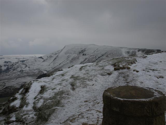
Looking across to the snow-capped Lose hill from Long Cliff.
The road that goes up the Winnat's pass is kept meticulously clear, as it's the ONLY way up these days since the old road collapsed for the last time back in 1979, and Winnat's was elevated to it's present status. Read about it here; http://en.wikipedia.org/wiki/Winnats_Pass
There is no 'official' path up on these buttresses atop Winnat's pass, but hell - this place is just TOO awesome to NOT be walked.
Sue CERTAINLY loves it as much as I do up here - in ANY weather!
.....and she's not worried about heights either.
The sheep were finding the ground slim pickings today - this is when they need the farmer to feed them.
Lunchtime, but not time to eat - it was FAR too cold to stop and take our gloves off. We decided to just press on, take the walk while we could, and eat in the comfort and warmth of the car after the walk. The day looked a bit 'angry' and dark, but it was still great to be out.
We reached the slopes of Mam Tor. It's a very popular place, but today we saw only two other people on the way up. This is how 'experts' think it used to look when it was a populated hill fort.
You can see why ancient man liked it up here - a super view point to spot anyone approaching the fort. This is the view through 'Mam nick' towards the Kinder Scout plateau.
Rushup edge, almost completely shrouded in the murk.
The Great ridge from Mam Tor to Lose hill. We wouldn't be doing the whole thing today, but dropping off at Hollins cross.
Hollins cross memorial cairn to Tom Hyett, erected in his memory by his walking club. It was here that we left the ridge to drop down the old coffin road to Castleton. You can read about the coffin road here; http://en.wikipedia.org/wiki/Hollins_Cross
A zoomed shot of Winnat's pass from the ridge. You can clearly see the buttresses we walked over earlier.
At last the day cleared a little to give me a good shot of the 'shivering mountain' of Mam Tor. Limestone meets gritstone here, and they are NOT happy bedfellows - that's why the road kept collapsing (and probably will collapse again in the future).
A nice shot of the pass, looking extremely cold in it's mantle of frost and snow.
As we walked back into Castleton, we spotted these doves. I think he was trying it on a bit! She didn't seem interested though - probably too cold :-)