Showing posts with label ladybower. Show all posts

Saturday, 24 November 2012

Calendar girl.

We turned over from October to November on the calendar, and there was a lovely autumnal scene around Ladybower. Sue decided that was where she'd like to go for our next walk, so I wrote the walk, and off we went. This was our first walk in Derbyshire for about five weeks, due to holidays, work commitments etc, so we were raring to go!
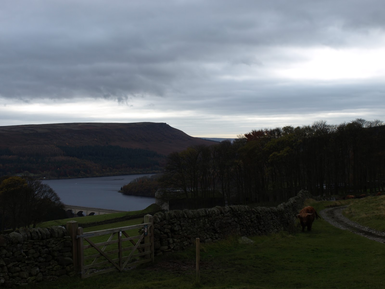
I decided to park on the viaduct to jig the walk start round a little. I usually park further up the reservoir. This is looking up Ladybower.
 We crossed the road, and immediately took the path up towards Crookhill farm. I really was hoping to see some mushrooms today, edible if possible, as the conditions were damp, BUT I had heard that it wasn't a good year for fungi. 
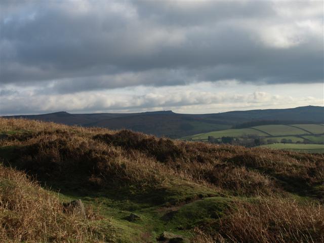
 After the initial steepness, the path eased a little. Looking back, we could see Bamford edge looking larger. This is a SUPER edge if you want pictures of the reservoir.
The twin peaks of Crook hill could be seen to our left. 
Looking back to Crook hill's distinctive peaks. 

 After all the recent wet weather, the going underfoot wad decidedly squidgy!
 We topped the rise, and took the path that runs alongside the wood. This area used to have terrible damage from four wheel drive vehicles and motorbikes, but since they were excluded, the path has recovered a lot. The view left was of the iconic lose hill to Mam tor ridge, part of the Castleton skyline walk.
 This time of the year, you can always count on gorse to add a splash of colour to an otherwise drab scene.
 We turned right to pass Lockerbrook farm and got our first glimpse of the reservoir since staring the walk. Normally, I would turn right, and go down through the woods to the Fairholme visitor centre, but that was the reason for parking in a different place - today we headed straight on, into the woods - a path I'd not walked before.
 One of my favourite photographic subjects - fungi. We'd not seen any of the edible variety, but this was a lovely bunch anyway.


 I also spotted this impressive, new bracket on a tree trunk.
 We were a week or two too late for the really splendid colours, but as the leaves had mostly fallen now, we had a warm, copper carpet to walk on.


 Just before we reached the valley and clearing, a Chinook helicopter flew by at ground level. One more minute, and I'd have got a video! We were now walking on level ground beside the Howden reservoir.
This trunk was suffering a full on attack by fungi, and it wouldn't be long before it crumbled down to earth. It looks like a grasping hand, reaching out of the ground,

Looking back to Howden dam, with water spilling over it.

 .....and forward to the Derwent dam towers
 The mighty Derwent dam. The water was rushing over Howden dam when we passed it, but it was barely trickling over the Derwent. The reservoir is brim-full, JUST.
 I usually only take photo's 'as is', but this one made a lovely subject for a sepia shot. It sort of gives the mood of this dreary, cold, damp time of they year.
 Something that we've only seen recently in the Peak District - hedge layering. Ingenious, the tall saplings are bent and chopped, and amazingly, they continue to grow, but horizontally! Less maintenance, and a thick cover for birds to nest in.
 We chose to cross to the 'quiet' side of Ladybower. It was a serene scene as we walked on the fallen leaves, the day all to ourselves.
 But, with the light fading, we reached the car. 
Looking up to Bamford, brooding over us as we left to go home. 
Our first walk for a while, and a really good day. Not bright, but dry, and for that, we were grateful.

Friday, 13 January 2012

Wham, bam........

 .......thank you.....for Bamford edge! Lots of recent rain meant that the fields were VERY muddy. Solution? Take to the edges. It's been a while since we were on our favourite edge, so that's where we made tracks for on Tuesday. We parked at the roadside (seeing as the once free car park at Newholme is now pay and display - it always happens), and drank in the first iconic view of the Ladybower viaduct. Somewhere this side of it once stood the village of Ashopton, now deeply submerged in the cold, acidic waters of the reservoir. To read about Ashopton, click here; http://en.wikipedia.org/wiki/Ashopton_Village
We started on our way up. Since the 'open access' laws were passed, this edge, and many, many other beautiful and wild places, have been accessible to all. Thank goodness for that law - places as lovely and unproductive as this should not be private. We were doing the edge 'backwards' today. In the past, we'd always done it South to North, as the wayfinding wasn't easy. Now that people are starting to come here more, paths are marked and being walked. 

 As we made our way up towards Bamford edge, the views over the reservoir, across the open countryside to Kinder Scout and beyond opened up more. The two prominent knolls in the foreground are Crook hill.
Sue makes her way among the browns of the bracken, along an obvious path, with Win Hill poking up in front. You can also see Lose hill as well on the right. 
NOW the view was good! The weather wasn't perfect, but it felt REALLY good to be out and high. 
The Wheel stones on Derwent edge, just peeping over the horizon. 
To our delight, we heard Buzzard calling overhead, and watched as two pair cavorted and soared in the sky above us.

The reservoir was full to overflowing - literally! By the time we got back from our walk and took a stroll across the top of the dam, this overflow would have stopped. I was SURE I had seen it going over when we were up here, and it was only when I checked the photo that I saw I was right. 
 Time to pause and reflect on what was around us.
Sue, silhouetted against the cloudy sky. 
 The sharp top of Bamford edge.
The wind, frost and rain can create some weird effects. 
 Looking south along the edge.
 The only blot on this fantastic landscape - Hope cement works.
The Ladybower dam, with Win hill behind. The dam was strengthened in the 90's, you can read about it here; http://en.wikipedia.org/wiki/Ladybower_Reservoir 
 Old mill stones left over and abandoned up on the edge.
Looking south to Froggatt and Cubar edges. 
 Bizarrely, we saw this mat at a stile - I know the fields are a bit muddy, but REALLY!!!!
We next had to cross the river Derwent by some stepping stones. No problem - there they are - just a little bit of water coming over them........... 
 Just hitch up the trouser bottoms, and we'd be ok, I reckon?
 "Now just hang on", said Sue - "let me check the map. I'm NOT going over those no matter WHAT you say......"
 We decided that it was a BIT too deep to go on, so we quickly re-wrote the walk and continued along the road. We then joined the bed of a disused railway that once served for the construction of the Ladybower dam. The view to our right of the edge we'd been on earlier was good. On a clear evening, the sunset lights this edge up flaming red. Sadly, tonight was not one of those nights.
Early signs of spring - the first catkins we've seen. 
As I said, we walked across the dam for one last look over the reservoir in the dying rays of the day, then it was back home. This was the view over the water from the middle of the dam towards Derwent edge.


Friday, 17 June 2011

A 10/10 day around Alport Castles


WHAT can I say about today, except it was darn near perfect! Weather, breeze, time, just everything! We decided to go to Alport Castles, one of the largest natural landslips in Europe, but this time we would 'attack it' from below (we almost always have gone along the top of the cliffs, in the past). Quote from Wikipedia;

The Alport Castles are a landslip feature in the Peak District of Derbyshire, said to be the largest landslide in the United Kingdom. They lie north of the Snake Pass and north west of Ladybower Reservoir. Alport Castles are part of the National Trust's High Peak Estate.
Debris from the landslide has produced several mounds, the largest of which — the "Tower" — from a distance resembles a full scale motte and bailey castle. The remote Alport Castles Farm lies on the River Alport below the site.
We parked at the side of Ladybower reservoir - looking decidedly low, after the recent dry spell.

It was nice to see the first foxgloves of the season, reaching up. We saw a very strange anomaly later in the walk - bluebells and foxgloves blooming side by side!

We crossed the quiet road and entered the woods up to Lockerbrook farm, now an outdoor centre. The dappled light and vibrant greens were at their best today.

Some of the foxgloves were really forward in their growth.

We passed the farm, and climbed up to the ridge beyond to get this spectacular view of the Castleton skyline, before dropping down past Hagg farm, once a YHA, now another outdoor centre.


More walking through dappled light for Sue. We LOVE to walk in the week when it's quiet. Often, we go the whole walk without seeing anyone else. The serenity of these places really does the heart & soul good! Last time we were in this area, Sue saw a small deer in the woods. Not today though.

BUT WAIT, WAIT!!!! WHAT'S THAT?????
Oh no - it's just a sheep ;-)

We were surrounded all day by beautiful moths and butterflies. We're not sure what this one is. The wings were a dull brown when closed, but a lovely pattern when open.


This was a feeder we followed. We were surprised to see small fish, that looked like trout, swimming in it. The water was very brackish and brown.

The National Park are implementing a very bold 40 year plan to return the Alport valley back to deciduous from its present coniferous status. It's a huge plan, but the valley should look much more pleasing to the eye, and be very much more wildlife-friendly when it's completed. Click on the picture to enlare it.

We followed the River Ashop through the woodlands valley, crossed the snake pass again, and started our walk up the Alport valley. Our skin tingled, as we got our first glimpse of our goal - Alport Castles. The 'Towers', as they are called, peeped over the horizon as we walked.

As we climbed higher and got closer, the view became more dominant.

Just past Alport farm, this stile has a convenient lifting top rung. I've seen this many times before on the Pembrokeshire Coastal path, only on theirs, it says; 'codwch' (which, I assume, means 'lift' in Welsh).

We could now see the Towers VERY clearly, and we knew we had a stiff climb to get to the cliffs above, but first, it was time for tiffin! We crossed this lovely bridge.........

.....and did a bit of pre-climb relaxing .

During lunch, Sue made friends with a small grasshopper, which insisted on perching on her finger!

....but then it was time to make our way onwards and upwards.
The Castles were calling!

The view back to the Alport valley. A green heaven, if ever there was one.

Sue had really got the bit between her teeth now.....COME ON LES - KEEP UP!

I was doing my best to catch her, but with all this loveliness around, it was easy to get distracted.

Then, as we passed a nick in the rocks, we saw that we had drawn level with the towers.
Wow. So close, and yet..........

Sue said; "let's just walk towards them a bit - see how far they are away......."

"Look, Les - I'm SURE we could get up there, you know? We've got time, if we just......."


OMG WOMAN!!!!!!!!!

"SUE - STOP IT - THEY WON'T GIVE YOU YOUR PENSION, IF THEY SEE YOU!"

Queen of the Castle.


Looking across to the cliff face. There was a curlew screaming in the sky here - as dramatic as this place is and was, that bird made it all the more so!
Hopefully, you can see a short video here; http://www.youtube.com/watch?v=tV1uSsar2Es


Looking Northwards.

Of course, I had to have a go too - Sue climbed down with the camera to get this shot.


It was time to stop all this shenanigans and get on with the walk. We still had lots of time, so no rush. There was a temporary bird hide on top of the cliffs and we had a short time in there too, watching for kestrels etc. Mainly though, it was a curlew day. We didn't mind, as this is one of our favourite bird calls.


After we climbed down and re-joined the path, we made our way onto the top of the cliffs. The views down to the towers is superb from here, but also the wide expanse of the northern moors opens up when you get on the top. It's often VERY windy up here, but today a gentle, cooling breeze accompanied us. The path turns right, and drops down the grouse moors to Howden reservoir. We saw MANY grouse butts to the left and right of the path. I would think the birds couldn't stand a chance against that lot.


Howden reservoir - greatly depleted.

Howden dam and the rhododendrons.

When full, the water runs over that middle section. Today, it was at least twenty feet below it!

The navvies who built the dams lived in a specially constructed village. Read more about it here; http://en.wikipedia.org/wiki/Birchinlee

The low water exposed these old rail supports.


We saw a big patch of these fungi, which I think are birch boletus, a member of the penny bun family. I have eaten these in the past, but they were past their best (and had been nibbled by slugs).

We reached the end of the walk at Derwent dam. You can see by the silt sides how this has receded. We called in at the cafe for a welcome cup of tea before making our way home, very happy with what today had given us.


Finally, just to show you how low Ladybower HAS been in the past, here's an old photograph I took and scanned.